I hope you're having a great holiday season. As we get ready to close out 2008, I finally managed enough time to update the Kansas camera scripts. I'm waiting for a whole slew of cameras from KDOT to come on line any day now, hopefully in the next month (is that too much to ask?). That will be exciting to say the least!
I've noticed a few of the WeatherBug/InstaCams down...not uncommon during the extended holiday break with nobody at school to maintain them. I won't remove them from the scripts at this point though and hope they return next week when schools are back in session.
Overall, it's been a rather productive year for the site. In addition to all of the Kansas camera scripts I continue to update, I added the Profiler and Upper Air data scripts in March. September brought the "Poor Man's Mesoanalysis", which was really fun.
And as this gift to you for the holidays, here's a couple of other scripts I threw together at some point during the year but never released. Maybe some of you will have a use for it, perhaps not. The first one is the Westar Outages Placefile. (Westar is a utility company that covers much eastern Kansas):
---------
;Westar Outages Placefile
Refresh: 5
Title: Westar Service Territory Outages
Image: https://www-11.westarenergy.com/outagemaps/CountyMaps/ServiceTerritory.JPG
36.82076, -99.05001, 0, 1
40.22578, -99.07336, 0, 0
40.10921, -93.08062, 1, 0
36.82076, -99.05001, 0, 1
40.10921, -93.08062, 1, 0
36.72185, -93.31198, 1, 1
End:
---------
This second one is for the Houston LDAR Network Realtime Data Display. Unfortunately, the network is down so it really doesn't serve much purpose until Texas A&M fixes the inoperative sensors around Houston.
---------
;Houston LDAR Lightning Placefile
Refresh: 2
Title: Houston LDAR Network Realtime Data Display
Image: http://atmo.tamu.edu/ciams/ldar/images/network.png
27.96037, -97.32729, 0, 1
31.41292, -97.39441, 0, 0
31.42265, -93.45268, 1, 0
27.96037, -97.32729, 0, 1
31.42265, -93.45268, 1, 0
27.98037, -93.48268, 1, 1
End:
---------
Happy New Year!
Wednesday, December 31, 2008
Saturday, November 22, 2008
New KDOT cameras...later
I got disappointing news earlier this week. I was hoping the rest of the new KDOT cameras would come on-line in November but in a press release, KDOT said it would be "early 2009." Oh well, they have been installed. Said KDOT: "25 new camera have been installed along I-70 between Goodland and Topeka; I-135 near Salina; and on US-75 in North Topeka. These are in addition to the existing eight camera views that are updated every 15 minutes and shown on the 511 Web site."
That's a good thing for travelers and the camera scripts.
That's a good thing for travelers and the camera scripts.
Thursday, November 6, 2008
Lil' Update
I just posted a very minor update to the Kansas camera scripts today. One camera in particular has been down for the last couple of weeks so I removed it.
Otherwise, I'm rather busy with work and family commitments so these updates may be rather infrequent for the time being. Thanks...
Otherwise, I'm rather busy with work and family commitments so these updates may be rather infrequent for the time being. Thanks...
Monday, October 13, 2008
Profiler status updated
I mentioned last Tuesday that I would be updating and streamlining the Profiler scripts once the data was back up on UCAR's site. I noticed the return this morning at work, so this afternoon we got down to business.
The scripts are nearly identical to the upper air scripts but instead they'll display 8 profiler sites in/around Kansas. Please refer to the "profiler.txt" placefile and the "profilerUCARbat.txt" batch file in the "Profiler/Upper Air Project" section on the right hand side of the page.
As always, there's incredible flexibility built in with this application. You can easily take out a site that doesn't apply to your needs and plug in the appropriate one. Just be sure to change the URL and file names in the batch file, get the correct lat/lon for it and you'll be good to go.
At this time, I'm not going to write a script that puts all 30+ sites that UCAR has into one placefile. It can be done...just not today!
Thursday, October 9, 2008
Update from KDOT
I want to thank Barb from KDOT for the nice email reply I received yesterday. She stated that the camera views from Garden City and Wichita are down because of firewall issues. It is unknown when they will be back online.
She also said that the new cameras (slated for along I-70) should be up in mid-November.
I say that's not a minute too soon! I know at least a couple of times last year when KDOT shut down parts of I-70 because of snow and blizzard conditions. I'm looking forward to the views they will provide for all users and for my camera scripts on GR3.
** UPDATE: SUNDAY 10/12 **
One back...one to go. Wichita returned Friday and has been steady ever since. C'mon GCK!
Tuesday, October 7, 2008
Update on Upper Air
I did a little house cleaning this morning with the Upper air data for GR3 (see my earlier post on this). I consolidated the individual raob placefiles into one, thus freeing up a few extra places in the placefile manager. I also added more raob sites. I'm now at 8 raob sites around my area, which just happens to be the limit (you can have up to 8 "Iconfiles" statements).
When I first put this together, I put each raob site into it's own placefile because of overlapping issues when displaying multiple sites. This time around, I simply changed the threshold statement from 250 to 100. As a result, you have to zoom in a ways to get the sites to pop up, far enough so that it ensures that they won't overlap one another.
I'll do the same to the profiler data once it is available again.
Monday, October 6, 2008
I missed the memo!
I was wondering this past weekend why I couldn't get my profiler scripts to work for GR3. I just figured there was a problem at NCAR/UCAR:
EFFECTIVE OCTOBER 1 2008 ALL NWS WIND PROFILER PRODUCTS WILL BE UNAVAILABLE FOR APPROXIMATELY 3 TO 5 WEEKS.
THE SUSPENSION IN AVAILABILITY OF WIND PROFILER DATA IS
NECESSARY BECAUSE OF RECENTLY INDENTIFIED IT SECURITY
THREATS. THE WIND PROFILER NETWORK CURRENTLY OPERATES ON OBSOLETE EQUIPMENT THAT CAN NOT SUPPORT NECESSARY IT SECURITY METHODS. INTERCONNECTION TO MAJOR NWS SYSTEMS EXTENDS THE VULNERABILITY TO OTHER NWS IT SYSTEMS.
There's no good time for this kind of data loss but I guess better now than the middle of April or May!!
Monday morning updates
I spent an hour this morning going through the Kansas camera scripts again. I found a couple of errors I overlooked from the previous update (my bad!). I also took out some other cameras that were down and replaced them with cameras that have returned to the fray.
I sent an email to the Kansas Department of Transportation this morning too. They still have 2 cameras down, one in Garden City and in Wichita, with the former down since 9/16. I don't have a timetable for return yet.
I sent an email to the Kansas Department of Transportation this morning too. They still have 2 cameras down, one in Garden City and in Wichita, with the former down since 9/16. I don't have a timetable for return yet.
Friday, October 3, 2008
A few tweaks
I spent a few minutes today updating the Kansas camera batch script. The issue was a URL change by KDOT which affected all 8 of their cameras (2 of them remain down though, even after the change). I'll continue to monitor things and won't make changes to any down camera(s) unless it's clear there's a persistent problem. Otherwise, I'll spend too much time switching/editing scripts.
Thursday, September 25, 2008
Camera Updates
If you've come over for the Poor Man's Mesoanalysis, please scroll down a bit! Thanks!
Otherwise, I've updated the kscambat.txt and kscampf.txt files for the WebCam Project. A few of the cameras have had lengthy downtimes. There's also a handful that haven't updated in the last week but I left them in for now in case they return soon. I'll give those cameras another week then we'll go from there.
Otherwise, I've updated the kscambat.txt and kscampf.txt files for the WebCam Project. A few of the cameras have had lengthy downtimes. There's also a handful that haven't updated in the last week but I left them in for now in case they return soon. I'll give those cameras another week then we'll go from there.
Tuesday, September 23, 2008
Poor Man's Mesoanalysis for GRLevel3
What do you get with you merge SPC's mesoanalysis page with GRLevel3? I call it the "Poor Man's Mesoanalysis."
If you have the URL2File and ImageMagick programs already on your computer through my "Web Cam Project", then you're in business! If not, see my earlier post on this. You'll simply need to run a batch file that will download, convert and cut the graphics. Once that's done and you have the placefiles loaded on GRLevel3, they will show up on your display!
In a perfect world, I'd like to use SPC's "sector graphics" since they have much higher resolution . There's a problem though: the locations are always changing (dang weather anyway!) The National Sector view however doesn't change.
First, I created a folder called (big surprise) SPC in the C:\Program Files\GRLevelX\GRLevel3 directory. I run the following batch file (located in the SPC folder) to get the following 16 products from the National Sector view:
URL2File http://www.spc.noaa.gov/exper/mesoanalysis/s4/mcon.gif mcon.gif
URL2File http://www.spc.noaa.gov/exper/mesoanalysis/s4/ttd.gif ttd.gif
URL2File http://www.spc.noaa.gov/exper/mesoanalysis/s4/thea.gif thea.gif
URL2File http://www.spc.noaa.gov/exper/mesoanalysis/s4/pchg.gif pchg.gif
URL2File http://www.spc.noaa.gov/exper/mesoanalysis/s4/sbcp.gif sbcp.gif
URL2File http://www.spc.noaa.gov/exper/mesoanalysis/s4/mlcp.gif mlcp.gif
URL2File http://www.spc.noaa.gov/exper/mesoanalysis/s4/laps.gif laps.gif
URL2File http://www.spc.noaa.gov/exper/mesoanalysis/s4/dcape.gif dcape.gif
URL2File http://www.spc.noaa.gov/exper/mesoanalysis/s4/lfch.gif lfch.gif
URL2File http://www.spc.noaa.gov/exper/mesoanalysis/s4/lclh.gif lclh.gif
URL2File http://www.spc.noaa.gov/exper/mesoanalysis/s4/shr6.gif shr6.gif
URL2File http://www.spc.noaa.gov/exper/mesoanalysis/s4/srh1.gif srh1.gif
URL2File http://www.spc.noaa.gov/exper/mesoanalysis/s4/ehi1.gif ehi1.gif
URL2File http://www.spc.noaa.gov/exper/mesoanalysis/s4/ehi3.gif ehi3.gif
URL2File http://www.spc.noaa.gov/exper/mesoanalysis/s4/scp.gif scp.gif
URL2File http://www.spc.noaa.gov/exper/mesoanalysis/s4/pwtr.gif pwtr.gif
convert mcon.gif -shave 300x200 -matte mcon.png
convert ttd.gif -shave 300x200 -matte ttd.png
convert thea.gif -shave 300x200 -matte thea.png
convert pchg.gif -shave 300x200 -matte pchg.png
convert sbcp.gif -shave 300x200 -matte sbcp.png
convert mlcp.gif -shave 300x200 -matte mlcp.png
convert laps.gif -shave 300x200 -matte laps.png
convert dcape.gif -shave 300x200 -matte dcape.png
convert lfch.gif -shave 300x200 -matte lfch.png
convert lclh.gif -shave 300x200 -matte lclh.png
convert shr6.gif -shave 300x200 -matte shr6.png
convert srh1.gif -shave 300x200 -matte srh1.png
convert ehi1.gif -shave 300x200 -matte ehi1.png
convert ehi3.gif -shave 300x200 -matte ehi3.png
convert scp.gif -shave 300x200 -matte scp.png
convert pwtr.gif -shave 300x200 -matte pwtr.png
Since GRLevelX placefiles support PNG, JPG and TIF files only, I use ImageMagick to not only change the SPC GIF files to PNG but to also cut out the portion of the map I want:


From there, I load the following placefile into GRLevel3 to display it:
;Moisture convergence from SPC
Refresh: 60
Title: Mstr Cnvg from SPC
Image: c:\Program Files\GRLevelX\GRLevel3\SPC\mcon.png
32.57435, -102.50050, 0, 1
42.80730, -103.78930, 0, 0
42.80355, -89.05626, 1, 0
32.57435, -102.50050, 0, 1
42.80355, -89.05626, 1, 0
32.52673, -90.64704, 1, 1
End:
This is what it looks like on my computer:

Here's the entire list of placefiles you'll need to make this work on your computer. You can give them any name you want.
As you can tell, these placefiles work for Kansas but include some neighboring states too. If you wish to mess with ImageMagick to change the "shave" numbers (which determines what part of the original graphic to cut out) and then mess with the lat/lon in the placefiles, please go for it! I unfortunately don't have the time to make other "sectors" for other areas of the country. My example will serve as a template for others who want to expand on my work. In addition, if you want to add more of SPC's National Sector products to this, simply look up the raw image(s) on their site.
If you're hoping my work can replace your AllisonHouse/F5Data subscription, you will be sorely disappointed! It's not even in the same league of high quality products they make! However, if you have a tight budget and want to give this a try, be my guest!
As always, if you have any comments, concerns or complaints: please let me know!
Friday, July 18, 2008
New Header
I had an artistic moment this afternoon so I made a new header for the blog. These moments don't come often so I took advantage of it while it was there. Enjoy.
Thursday, July 17, 2008
Updates!! (Finally)
This has been in beta testing for a couple of weeks but I finally had enough time today to get it finished...
For a while now, I've been wanting to clean up the camera files. So, I have taken the previously named "ks1", "ks2" and "ks3" files and converted them to just one placefile and one bat file. While this does make each respective file longer, it also allows the user to have just one placefile loaded for the Kansas cameras instead of 3. I don't know about you but my placefile manager is almost full!!
I also have changed the "gr3cambat.txt" file too.
Any questions, comments or concerns...please let me know!
Rodney
Wednesday, June 18, 2008
Sorry for Lack of updates lately
Needless to say with the severe weather season ongoing, I've had no time for side projects, including updates for the web cameras and such. Hopefully the death ridge will build in soon and things will calm down and dry out. Once that happens, I can resume some other projects.
Thursday, March 27, 2008
Crude Profiler and Upper air data displayed on GRLevel3
A few days ago I was thinking, "I'd like to see profiler data on GRLevel3". I've been working on this little project since then and I finally have it the way I like.
It works very similar to the web camera scripts that I've maintained for the last year and a half. The scripts run locally on your computer using the programs URL2File and ImageMagick. (If you are new to the web cameras, see my initial "how-to" post.)
Using URL2File, I downloaded profiler data (.gif files) available on the NCAR/RAP Real-Time Weather Data page. After I saved an initial picture, I used the ImageMagick scripting to resize it and combined it with a transparent triangle (pointer.png). I then wrote a placefile script for each profiler site, so the operator could toggle it on/off. There's just too much overlap/screen blockage if you try to display them all in one placefile (trust me, I tried it already!) The final result looks like this:
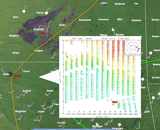
It's by no means perfect but if you want a quick and dirty method to display the data, then you're in luck.
Here's how I set everything up:
On my computer, I have the following directory set up:
C:\Program Files\GRLevelX\GRLevel3\pictures\profiler
The "pictures" folder is where all of the webcam pics go. To organize things, I created a "profiler" folder. This is where I put the "profilerUCAR.bat", "pointer.png" and "sitedown.jpg", the latter of which is used by the scripts in case the site is down (to keep the .bat file from freezing up). Remember: before you can operate the script, you must change the name from "profilerUCARbat.txt" to "profilerUCAR.bat" (without the quotation marks of course).
Here's how the first block of the script looks:
URL2File http://www.rap.ucar.edu/weather/upper/lmn_wp.gif lmn.jpg ||convert sitedown.png lmn.jpg
convert lmn.jpg -resize 400x400! lmntemp.png
convert pointer.png lmntemp.png +append lmn.png
The rest of the script can be found on the "Profiler/Upper Air Project" on the right part of my blog. The placefile for the Lamont, OK site looks like this:
; Crude Profiler data for GRLevel3
; by Rodney Price 3/26/08
Refresh: 10
Title: Lamont, OK Wind Profiler
Threshold: 250
IconFile: 1, 1000, 400, 500, 200,"C:\Program Files\GRLevelX\GRLevel3\pictures\profiler\lmn.png"
Font: 1, 11, 1, "Arial"
Icon: 36.68, -97.47, 0,1,1, "Lamont, OK Wind Profiler\nHourly data"
Right now, I have worked on just 6 sites for my local area but it will serve as a template so that you can easily add sites for your area if you wish.
In addition, I changed up the code a bit to also display the UCAR upper air data. It operates pretty much the same as the profiler scripts. I created another folder in the "pictures" directory for "upperair" (to keep it separate from the profiler stuff). Put the file "raobsbat.txt" in that folder (and change the name to "raobs.bat"). In addition, a copy of the "pointer.png" and "sitedown.png" file each must be in this folder too so the .bat file will work properly.
The TOP and DDC sites can also serve as a template if you wish to add more sites.
I hope all of this made sense. Please let me know if you have any questions or problems!
Rodney
Saturday, February 23, 2008
Whoops...it's been while
Good evening!
I've been a little busy with projects for the upcoming Spring severe weather season so sorry for the shortage of updates here. I'll try to get a few more updates next week. I've found a few more cameras to add to the mix.
I've been a little busy with projects for the upcoming Spring severe weather season so sorry for the shortage of updates here. I'll try to get a few more updates next week. I've found a few more cameras to add to the mix.
Tuesday, January 22, 2008
More Updates
Today I added 3 "new cameras" to the ks3 scripts. These cameras have actually been used before but had been unavailable for quite some time. I finally found a round about link for the Wamego camera which I hadn't been able to use in over a year I think.
Wednesday, January 9, 2008
Project completed!
I hope 2008 is treating you well thus far!
I've made a slight change in all of the camera batch files. When you can't connect to a camera, it will give you a "Camera Down" image instead. I've tested this over the last week and it works fine and is stable. Here's an example of the slight code change in the batch files:
URL2File http://www.bburg.com/cam/cam1.jpg springf.jpg ||convert camdown.png springf.jpg
This last part:
||convert camdown.png springf.jpg
is what has been recently added to this line. The new segment only runs if you can't connect to the camera URL. It basically takes the default camdown.png image and puts it in the place of the image (in this case, "springf.jpg"). In the past, if say camera 10 was down, you would see camera 11 in it's place and so on and so forth. The script will have the camdown image in place of the camera's normal image and the rest of the sequence won't be messed up. (I hope that makes sense!)
You'll want to download the camdown.png file and place it in the GRLevel3\pictures folder.
While this does fix the problem if the URL is down, it does NOT resolve the problem of having an OLD image on the site. The scripts cannot differentiate between an image that's 2 minutes old or 2 days old.
Speaking of really OLD images, all of the web camera images from KCTV are down. I'm not sure what the issue is but this affects the "ks2" and "mo1" scripts. Here's a prime example of where this new code cannot help in cases like this.
I've also found more new cameras here in Kansas, so I've added the "ks3cambat.txt" and "ks3cams.txt" files to the list.
If you have any problems, please let me know!
Rodney
Subscribe to:
Posts (Atom)