It works very similar to the web camera scripts that I've maintained for the last year and a half. The scripts run locally on your computer using the programs URL2File and ImageMagick. (If you are new to the web cameras, see my initial "how-to" post.)
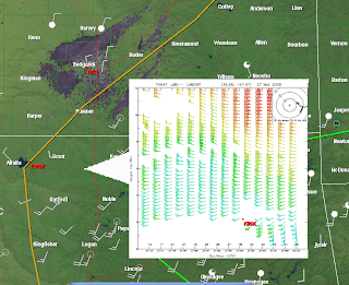
Using URL2File, I downloaded profiler data (.gif files) available on the NCAR/RAP Real-Time Weather Data page. After I saved an initial picture, I used the ImageMagick scripting to resize it and combined it with a transparent triangle (pointer.png). I then wrote a placefile script for each profiler site, so the operator could toggle it on/off. There's just too much overlap/screen blockage if you try to display them all in one placefile (trust me, I tried it already!) The final result looks like this:

It's by no means perfect but if you want a quick and dirty method to display the data, then you're in luck.
Here's how I set everything up:
On my computer, I have the following directory set up:
C:\Program Files\GRLevelX\GRLevel3\pictures\profiler
The "pictures" folder is where all of the webcam pics go. To organize things, I created a "profiler" folder. This is where I put the "profilerUCAR.bat", "pointer.png" and "sitedown.jpg", the latter of which is used by the scripts in case the site is down (to keep the .bat file from freezing up). Remember: before you can operate the script, you must change the name from "profilerUCARbat.txt" to "profilerUCAR.bat" (without the quotation marks of course).
Here's how the first block of the script looks:
URL2File http://www.rap.ucar.edu/weather/upper/lmn_wp.gif lmn.jpg ||convert sitedown.png lmn.jpg
convert lmn.jpg -resize 400x400! lmntemp.png
convert pointer.png lmntemp.png +append lmn.png
The rest of the script can be found on the "Profiler/Upper Air Project" on the right part of my blog. The placefile for the Lamont, OK site looks like this:
; Crude Profiler data for GRLevel3
; by Rodney Price 3/26/08
Refresh: 10
Title: Lamont, OK Wind Profiler
Threshold: 250
IconFile: 1, 1000, 400, 500, 200,"C:\Program Files\GRLevelX\GRLevel3\pictures\profiler\lmn.png"
Font: 1, 11, 1, "Arial"
Icon: 36.68, -97.47, 0,1,1, "Lamont, OK Wind Profiler\nHourly data"
Right now, I have worked on just 6 sites for my local area but it will serve as a template so that you can easily add sites for your area if you wish.
In addition, I changed up the code a bit to also display the UCAR upper air data. It operates pretty much the same as the profiler scripts. I created another folder in the "pictures" directory for "upperair" (to keep it separate from the profiler stuff). Put the file "raobsbat.txt" in that folder (and change the name to "raobs.bat"). In addition, a copy of the "pointer.png" and "sitedown.png" file each must be in this folder too so the .bat file will work properly.
The TOP and DDC sites can also serve as a template if you wish to add more sites.
I hope all of this made sense. Please let me know if you have any questions or problems!
Rodney

No comments:
Post a Comment